Lake Okeechobee continued to rise this week, but inflows from the north have started to lessen.
Join our family of readers for as little as $5 per month and support local, unbiased journalism.
Already have an account? Log in to continue. Otherwise, follow the link below to join.
Please log in to continue |
Lake Okeechobee continued to rise this week, but inflows from the north have started to lessen.
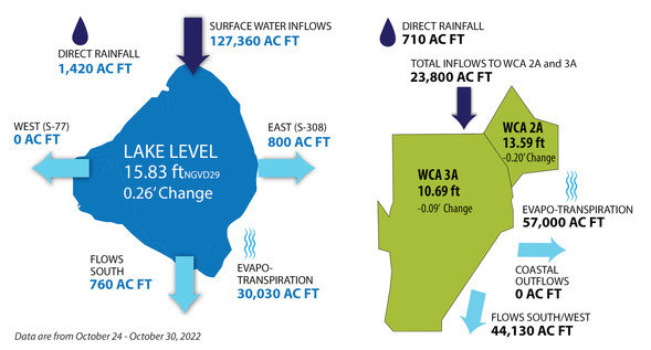
From Oct. 24-Oct. 30, the lake received about 1,420 acre feet via direct rainfall and about 127,360 acre feet in flow from the north. Since Hurricane Ian, most of the flow to the lake has come down the Kissimmee River. Ian dumped about 12 inches of rain on the Kissimmee/Orlando area and it has taken weeks to drain off.
According to the Nov. 2 Ecological Conditions Report from the South Florida Water Management District, the lake is above the upper limit of the ecological envelope.
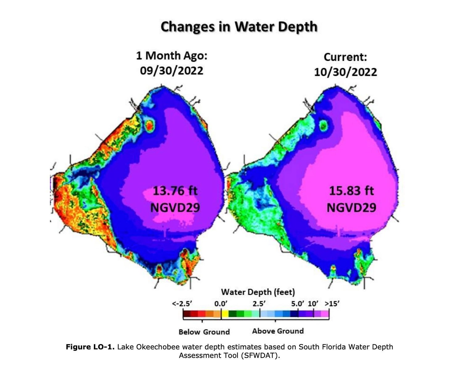
On Nov. 2, the lake level was 15.89 feet above sea level. When the lake level reaches 15.5 feet, the marshes are inundated with water. As the lake level rises above 15.5 feet, water starts to stack up against the sides of the Herbert Hoover Dike, an earthen berm which surrounds the big lake. The dike was built to project the surrounding areas from flooding.
Average daily inflows (excluding rainfall) and outflows (excluding evapotranspiration) decreased from the previous week.
The most recent satellite image from the National Oceanic and Atmospheric Administration (NOAA) Harmful Algal Bloom Monitoring System showed a very low bloom potential in the southwestern part of the lake, a decrease from the previous week.
The Oct. 17-19, 2022, routine water quality and phytoplankton survey of the lake revealed that communities were mixed. No microcystin toxins were detected.
For the seven-day period ending Nov. 3, total inflows to the lake averages 4,630 cubic feet per second (cfs).
No lake water has been released to the St. Lucie River since April 2021. Some water is released from the lake at Port Mayaca into the C-44 canal (St. Lucie canal) to maintain the canal level for navigation and water supply. However, lake water is not released from the C-44 canal through the St. Lucie Lock. For the period of Oct. 24-30 about 800 acre feet of water flowed from Lake O into the C-44 canal.
To the west, for the seven-day period ending Nov. 3, flow from the lake into the Caloosahatchee River averaged 278 cfs. Flow at the Franklin Lock, which is more than 40 miles from Moore Haven where the lake water enters the river, averaged 916 cfs. Most of the water flowing through the Franklin Lock is local basin runoff. Freshwater flow at the Franklin Lock is in the optimal range for the Caloosahatchee Estuary. During the dry season, the river needs some flow from the lake to ensure the salinity levels do not rise too high. When there is rainfall in the basin, the U.S. Army Corps of Engineers releases less water from the lake. The current target flow set for the Franklin Lock is an average of 1,200 cfs,
Some lake water is now flowing south. From Oct. 24-Oct. 30, about 740 acre feet of water went south.
Most of the water leaving Lake O is due to evapotranspiration, a combination of evaporation and plant transpiration. Oct. 24-Oct. 30, the lake lost about 30,030 acre feet to evapotranspiration.