Lake Okeechobee remains high, with water levels nearly a foot above the lake’s ecological envelope.
Join our family of readers for as little as $5 per month and support local, unbiased journalism.
Already have an account? Log in to continue. Otherwise, follow the link below to join.
Please log in to continue |
OKEECHOBEE -- Lake Okeechobee remains high, with water levels nearly a foot above the lake’s ecological envelope.
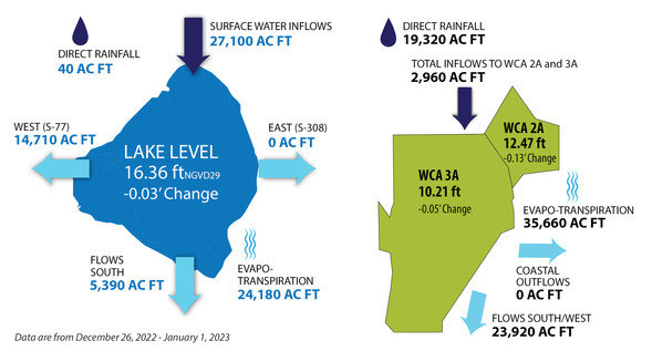
For the last week of December, most of the water leaving Lake Okeechobee was via evapotranspiration, the combination of evaporation and plant transpiration. According to the South Florida Water Management District Jan. 4 Environmental Report, 14,710 acre feet of water from Lake Okeechobee flowed west to the Caloosahatchee, 5,390 acre feet of water flowed south, and 24,180 acre feet was lost to evapotranspiration during the week of Dec. 26, 2022-Jan. 1, 2023. For that same period, 27,100 acre feet of water flowed in from the north, and direct rainfall into the lake contributed 40 acre feet of water.
No water from the lake has been released east to the St. Lucie River since April 2021.
The U.S. Army Corps of Engineers has set the target flow at the Franklin Lock at 2,000 cubic feet per second (cfs). The Franklin Lock is more than 40 miles from Moore Haven, where water from the lake enters the Caloosahatchee River. The flow measured at the Franklin Lock is a combination of local basin runoff and lake water.
South of Lake Okeechobee, direct rainfall is taking up most of the capacity in the Water Conservation Areas (WCAs). For the week of Dec. 26-Jan. 1, about 19,320 acre feet of water fell into the WCAs via direct rainfall. Inflows accounted for 2,960 acre feet. About 23,920 acre feet flowed south from the WCAs to Everglades National Park. As with the lake, most of the water leaving the WCAs is via evapotranspiration.
North of the lake, most of the Kissimmee Chain-of-Lakes are within their regulation schedules, although releases continue to be made from some lakes for local basin runoff. Weekly average discharges on Jan. 1, 2023, at S-65 and S-65A (where the water enters the Kissimmee River) were 1,300 cfs and 1,400 cfs, respectively, both of which had not changed from the previous week. Mean weekly water depth on the Kissimmee River floodplain decreased slightly from the previous week, from 0.59 feet to 0.57 feet.
Dissolved oxygen levels in the Kissimmee River continue to improve. The weekly average concentration of dissolved oxygen in the Kissimmee Rive increased from 5.9 milligrams per liter (mg/L) the previous week to 7.6 mg/L for the week ending Jan. 1, Levels below 5 mg/L can be stressful to largemouth bass and other sensitive species.
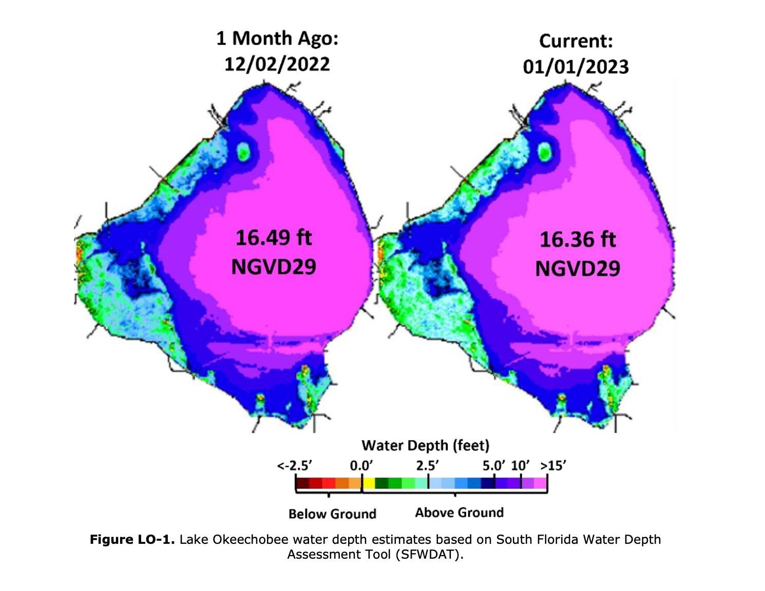
Lake Okeechobee stage was 16.36 feet NGVD on January 1, 2023, which is 0.03 feet lower than the previous week and 0.13 feet lower than a month ago. (NGVD stands for National Geodetic Vertical Datum, the national standard reference for elevations.) Levels above 15.5 feet are above the lake’s ecological envelope. In 2022, lake stage was within the ecological envelope for 70% of the year, and above it for 30% of the year. This is the third year in a row lake stages have exceeded 16 feet NGVD at the beginning of the dry season and is the highest lake stage at this time of year for more than two decades.
When the lake is at 15.5 feet, the marshes around the edges of the lake are completely inundated with water. If the lake rises above, 15.5 feet, water stacks up against the dike. This can damage the marshes, which help clean the lake water and provide habitat for fish and wildlife. In addition, if the water rises faster than the plants can grow, this damages the lakes submerged aquatic vegetation (SAV) and lake levels below 12 feet are needed for sunlight to reach the lake bottom for new SAV to sprout.
The most recent satellite image (Jan. 2, 2023) from the National Oceanic and Atmospheric Administration (NOAA) Harmful Algal Bloom Monitoring System showed low bloom potential across the lake.