On April 15, the U.S. Army Corps of Engineers reduced flows from Lake Okeechobee to the Caloosahatchee River and stopped ...
Join our family of readers for as little as $5 per month and support local, unbiased journalism.
Already have an account? Log in to continue. Otherwise, follow the link below to join.
Please log in to continue |
On April 15, the U.S. Army Corps of Engineers reduced flows from Lake Okeechobee to the Caloosahatchee River and stopped releases to the St. Lucie River, with the prediction the remainder of the dry season would be dry and hot. USACE predicted evapotranspiration and lake releases south for water supply and would drive Lake O levels down to 13 feet before the wet season rains start.
On April 14, Lake Okeechobee was 14.22 feet (above sea level). On April 18, the lake level was 14.20 feet,
However, as many USACE commanders have commented in the past, “most of the time, Mother Nature is in charge.” Over the past week, the Big O area has experienced some storms, edging the lake level back up.
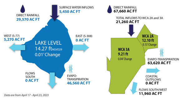
On April 23, the lake level was 14.27 feet. On April 25, Lake Okeechobee was at 14.30 feet. For reference, 1 inch on Lake Okeechobee equals about 12 billion gallons of water.
According to data from the South Florida Water Management District for the period April 17-23:
• Lake O releases to the Caloosahatchee totaled 5,270 acre feet of water (about 1.7 billion gallons of water).
• The lake lost 46,560 acre feet to evapotranspiration (about 15.17 billion gallons of water).
• No lake water was released east to the St. Lucie Canal.
• No lake water was released south: Sufficient rain south of the lake took care of water supply needs in that region. Due to direct rainfall south of the lake, there was no capacity in the stormwater treatment areas (STAs) to accept water from the lake. Direct rainfall south of the lake into the water conservation areas (WCAs) totaled 67,660 acre feet (22 billion gallons.) Flow southwest from the WCAs to Everglades National Park (ENP) totalled 11,960 acre feet (3.9 billion gallons). All of the water control structures under the Tamiami Trail are open, with the exception of the S-12A and S-12B structures, which are closed 9 months of the year to protect the nesting grounds of a subpopulation of the endangered Cape Sable Seaside Sparrow. The Tamiami Trail, which cuts through the Everglades from Tampa to Miami, separates the WCAs from ENP.
• Direct rainfall into the lake totalled 29,570 acre feet (About 9.6 billion gallons).
• Flow from the north into the lake totalled 5,450 acre feet (about 1.78 billion gallons),
With just about a month before the “official” start of the wet season, what does that mean for Lake O?
Most of the time, Mother Nature is in charge.