Water is moving south under the Tamiami Trail from the Water Conservation Areas (WCAs) south of the lake at about 1,700 cubic feet per second (cfs)
Join our family of readers for as little as $5 per month and support local, unbiased journalism.
Already have an account? Log in to continue. Otherwise, follow the link below to join.
Please log in to continue |
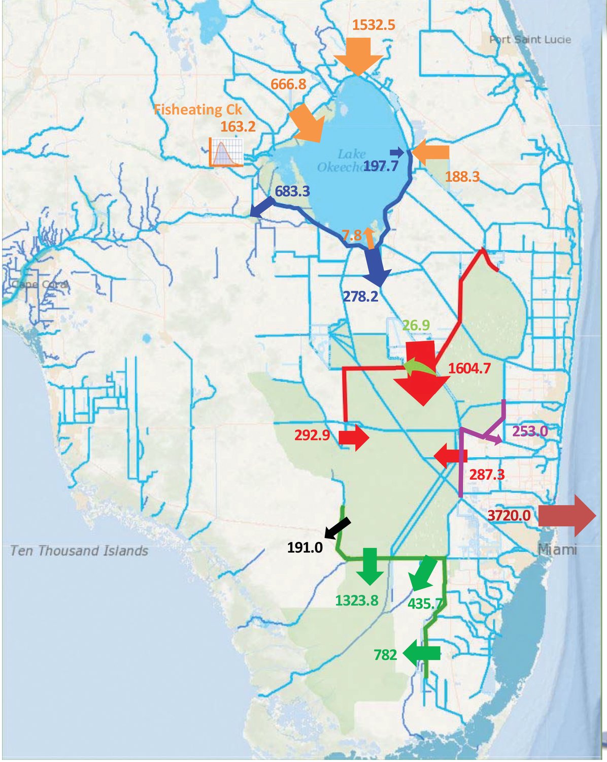
WEST PALM BEACH – Water is moving south under the Tamiami Trail from the Water Conservation Areas (WCAs) south of the lake at about 1,700 cubic feet per second (cfs) to Everglades National Park and Florida Bay, according to information shared at the March 11 meeting of the South Florida Water Management District Governing Board.
At the same time, water from Lake Okeechobee is flowing south at about 1,000 cfs into the canals and stormwater treatment areas that flow into the WCAs. With the bottom of the system opened up to flow 1,700 cfs, why can’t more water move south from the lake?
The difference comes from direct rainfall south of the lake. SFWMD Chief District Engineer John Mitnik explained the area south of the Big Lake is still drying out from the extreme heavy rainfall in the fall and from Tropical Storm Eta.
Since May 2020, the water conservation areas (WCAs), received about 2.1 million acre feet of surface water flows plus about 3.5 million acre feet of direct rainfall over the WCAs, which are west of the East Coast Protection Levee. In that time, about 3.7 million acre feet of rain that fell on the urban areas east of the East Coast Protection Levee was moved to tide.
The levee, Governing Board Member Ron Bergeon often explains, divides the part of the Everglades the state chose to preserve from the part of the original Everglades the state chose to drain for development.
Mitnik said flows into Everglades National Park have totalled about 1.7 million acre feet since May 2020. Flow is currently 1,700 cfs, which is what the schedule calls for to provide the water needed by Everglades National Park and Florida Bay.
This past year, the southern end of the system received 51 inches of rain. That excessive amount of rainfall filled up the WCAs.
Mitnik said about half of the 1,000 cfs leaving Lake Okeechobee to flow south is used for water supply and the rest is flowing into the stormwater treatment areas (STAs) south of the lake, then into the WCAs.
“From the lake’s prospective, water out is water out,” he said. “It’s leaving the lake. It doesn’t matter if it’s being used for water supply or it goes to the STAs.”
Mitnik said the flow formula calls for 1,700 cfs to meet the needs for Everglades National Park and Florida Bay, which is what they are moving now.
Since May 2020, total inflows to Lake Okeechobee have been about 2.58 million acre feet.
Flow to Caloosahatchee River has been 1.6 million acre feet with roughly 600,000 acre feet coming from Lake Okeechobee. The Caloosahatchee needs flow from the lake during the dry season to maintain the right salinity levels in the estuaries. The optimum dry season freshwater flow is about 1,000 cubic feet per second according to Lee County officials, which equals about 1,983 acre feet per day or about 360,000 acre feet for the six months of the dry season. Although freshwater flow to the Caloosahatchee River is currently at 2,000 cfs, that is still considered within the beneficial range. Levels below 450 cfs are considered harmful because the salinity levels are too high. Levels above 2,800 cfs are considered harmful because the salinity levels drop too low.
The St. Lucie does not need any freshwater flow from the lake. The C-44 canal, a man-made waterway linking the lake with the St. Lucie River, made it possible for boat travel coast to coast through the Lake Okeechobee Waterway. When the lake is below 14 feet, water may backflow from the C-44 watershed in the lake. When the lake is above 14 feet, water managers can use gravity flow to send water from the lake to the St. Lucie River. The St. Lucie River’s connection to the ocean is also man-made.
Since May, flow to the St. Lucie River from the C-44 canal has been about 280,000 ace feet including 170,000 acre feet from Lake Okeechobee. Of note, early in 2020, when the lake was below 14 feet, about 100,000 acre feet backflowed from the C-44 into the lake which means the C-44 has gotten the equivalent of all of that local basin water back plus about 70,000 acre feet of lake water.
Flow to the St. Lucie since May 2020 has also included 450,000 acre feet from C-23 and C-24 basins.