
LAKE OKEECHOBEE – National Oceanic and Atmospheric Administration (NOAA) satellite imagery is one tool water mangers use to predict cyanobacteria potential on Lake Okeechobee, but it does not …
Join our family of readers for as little as $5 per month and support local, unbiased journalism.
Already have an account? Log in to continue. Otherwise, follow the link below to join.
Please log in to continue |
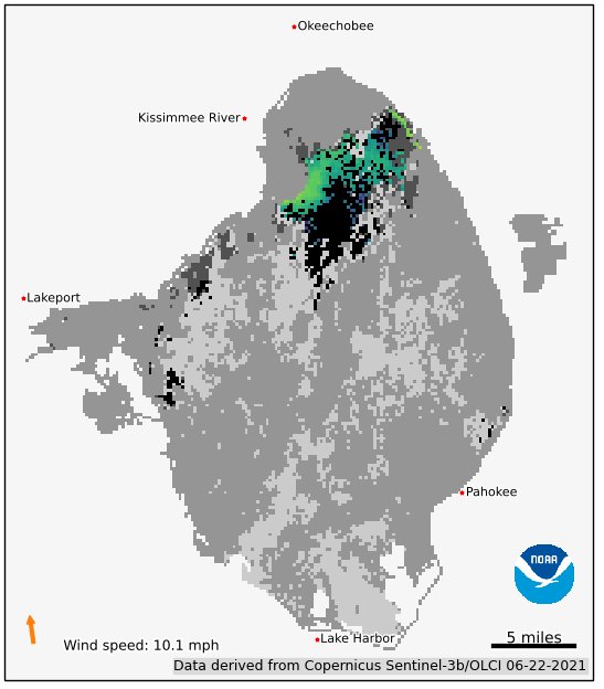
LAKE OKEECHOBEE – National Oceanic and Atmospheric Administration (NOAA) satellite imagery is one tool water mangers use to predict cyanobacteria potential on Lake Okeechobee, but it does not necessarily show where an algal bloom can be found. “It is a potential and it can alert you to go out and take samples, but to rely on it ... not a good idea,” Dr. James Sullivan, Florida Atlantic University Harbor Branch, explained at the June 23 meeting of the Florida Blue-Green Algae Task Force.
“We have attempted to compare the satellite imagery with the data that we have collected in the lake in terms of looking at the chlorophyll A concentrations as well as the presence of the dominant taxa. Somethings are surprising. If you just relied on the satellite image, you may reach an incorrect conclusion about what is really going on. That’s why we call it ‘bloom potential.’ It’s often not corroborated. You may see surprisingly low or high concentrations of chlorophyll A that are not revealed in the images.
“Lake Okeechobee is one of the most difficult lakes to do remote sensing on because of the amount of dissolved organic material that confuses the signal,” said Sullivan. “It will look like there is a lot of chlorophyll. No, it’s just dissolved organic matter than pollutes the satellite signal.”


