
The National Oceanographic and Atmospheric Administration satellite images used to estimate the “potential” for algal blooms in Lake Okeechobee and other bodies of water are useful tools …
Join our family of readers for as little as $5 per month and support local, unbiased journalism.
Already have an account? Log in to continue. Otherwise, follow the link below to join.
Please log in to continue |
The National Oceanographic and Atmospheric Administration satellite images used to estimate the “potential” for algal blooms in Lake Okeechobee and other bodies of water are useful tools for scientists, but sometimes misunderstood by the public.
According to Sachi Mishra, satellite oceanographer with the National Centers for Coastal Ocean Science, NOAA National Ocean Service, the satellite detects spectra of light the human eye cannot see. The computer program creates a color-coded image with red in the areas most likely to have surface scum, with decreasing concentrations of algae indicated by areas in orange, yellow, green and blue. Black indicates areas where no cyanobacteria is detected.
The satellite looks at the amount of light in many wavelengths. To detect cyanobacteria (also called blue-green algae), NOAA uses several wavelengths of red and near-infrared light (this infrared detects brightness, not temperature). For water, only the light from the upper 1-3 feet is measured. Differences between these bands detect pigments that are characteristic to cyanobacteria.
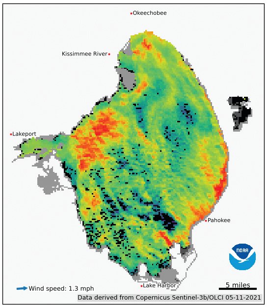
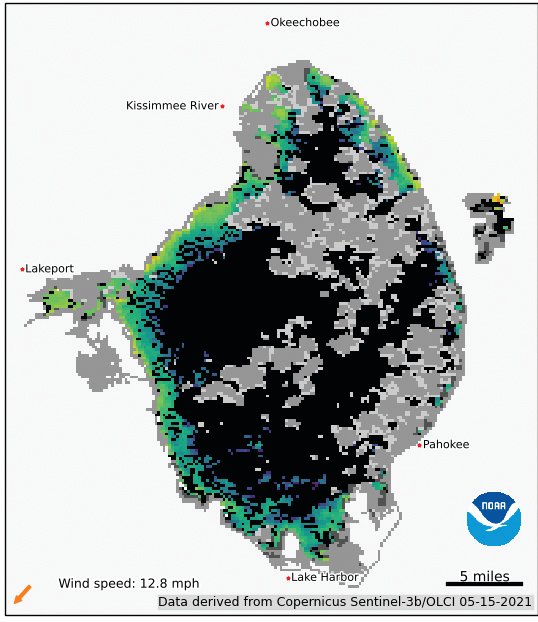
The satellite can see details humans cannot see, so it can see high concentrations even when there is not a visible surface scum. If wind is above 5 knots, the scum doesn’t form, but the bloom is still there in the water column. Cyanobacteria blooms can change from day to day, or even during the same day. If winds change through the day, the amount of surface scum will change.
Cyanobacteria are microscopic organisms found in all freshwater lakes, ponds, river and streams. When they reproduce rapidly into concentrations sufficient to be visible to the human eye, it is referred to as a “bloom.” To reproduce rapidly into a bloom, cyanobacteria need hot weather, nitrogen, phosphorus, sunlight and little water movement.
Cloudy weather, which deprives the cyanobacteria of sunlight, can cause a die-off. Some cyanobacteria (like Anabaena) are “nitrogen fixers” and can use nitrogen from the air. Others (like Microcystis aeruginosa ) depend on nitrogen available in the water. If a dominant cyanobacteria that is not a “nitrogen fixer” uses up the available nitrogen in the water, this can also cause the bloom to die. When that happens, if there is still sufficient phosphorus in the water, a nitrogen-fixer cyanobacteria may become dominant and create a new bloom.
The NOAA images are derived from Copernicus Sentinel-3 satellite data from the European Organization for the Exploitation of Meteorological Satellites (EUMETSAT) and are processed by NOAA’s National Centers for Coastal Ocean Science. The NOAA computer program uses the data collected by the satellite images to postulate the potential for algal blooms.
Why does “bloom potential” matter? According to the National Centers for Coastal Ocean Science, “Reported in every coastal state, HABs (harmful algal blooms) have caused an estimated $1 billion in losses over the last several decades to coastal economies that rely on recreation, tourism and seafood harvesting. Blooms can lead to odors that require more costly treatment for public water supplies. NCCOS conducts and funds research that helps communities protect the public and combat blooms in cost-effective ways, and we are breaking new ground in the science of stopping blooms before they occur.”
The satellite images are a snapshot of Lake Okeechobee at a moment in time on a given day. Fishermen have noted that an area shown in red on the map, indicating high potential for an algal bloom, may not have any visible algae at all. Cyanobacteria, also called “blue-green algae,” cannot move on their own. They are pushed by wind and carried by water flow. Cyanobaterica can rise and fall in the water by inflating and deflating gas vesicles.
When viewing the NOAA images, also keep in mind that of the 28 species of cyanobacteria documented by the U.S. Geological Survey in the Lake Okeechobee Waterway— which includes the St. Lucie River, the St. Lucie Canal (C-44 Canal), Lake Okeechobee and the Caloosahatchee River — only about 25% are capable of producing toxins. Cyanobacteria capable of producing toxins do not always do so. Scientists are still trying to understand what causes them to release toxins. Some research indicates toxin levels may increase in enclosed areas of stagnant water where a cyanobacteria bloom may become more dense and/or in areas where high levels of nitrogen are present in the water.
Because you cannot tell whether an algal bloom contains toxins by looking at it, health officials advise people stay out of water where algae is visible and keep pets out of water where algae is visible.
The NOAA website is updated several times a week with the most recent image available. Some days when a Satellite image is taken, it is not usable due to weather conditions.


