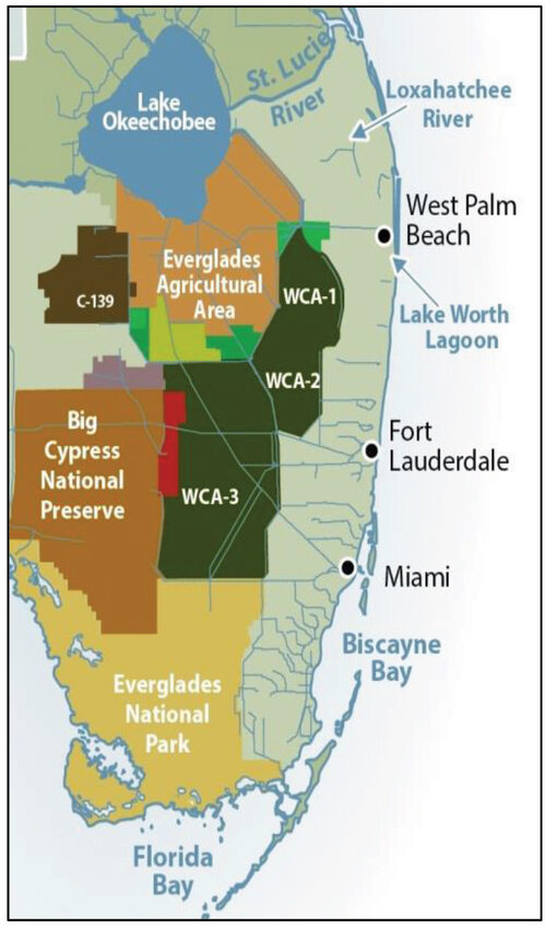
High water levels in the water conservation areas (WCAs) north of the Tamiami Trail are endangering wildlife in the Everglades. Where did all that water come from? According to South Florida Water Management District (SFWMD) data, about 70% is from direct rainfall.
According to the SFWMD data, from May 15 to Oct. 10, about 2.8 million acre feet of rain fell on the WCAs, which cover approximately 864,000 acres. In that same time period – 553,700 acre feet flowed through the water control structures out of the WCAs and under the Tamiami Trail.
Since Jan. 1, about 1 million acre feet of water has flowed under the Tamiami Trail, according to the U.S. Army Corps of Engineers (USACE).
Before the Central & South Florida Flood Control Project (C&SF), rain that feel in WCA-3A area sheet flowed east and south, explained Tom MacVicar, of MacVicar Consulting South Florida Water Resource Specialists.
MacVicar, a former employee of SFWMD, built the first computer model they had of the system.
MacVicar said the C&SF project was in response to the Great Florida Flood of 1947 which left cities along the east coast flooded.
“What the C&SF project did – the first piece of the project they did was the East Coast Protection Levee,” he explained. Flow east is now blocked by that levee which stretches from West Palm Beach to Miami.
“Before the project was built, the water flowed toward the ocean,” said MacVicar. “Now people are living there.”
Initially, the water flowed under the trail through culverts and even over the road during heavy storms. Heavier traffic use and heavier vehicles led to improvements to roadway. Flow south out of the water conservation areas is now blocked by the L-29 and L-28 levees. Water control structures in the levees control the flow.
“In 1963, the corps built the L-29 levee to hold the water back in the conservation area,” MacVicar explained. The L-28 levee is on the west side of the WCA.
MacVicar said USACE initially overestimated how much water they could move through the water control structures. “The corps thought they could get 12,000 cubic feet per second (cfs) out of each of the S-12s,” he said. “They get about 8,000 cfs out of all of them put together.”
“The corps’ original design shows they had a pretty good handle on how much capacity they would need,” he said. “But they’ve never been able to achieve anything close to that.”
The capacity they do have to send water through the levees and under the Tamiami Trail is currently restricted by the U.S. Fish and Wildlife Service (USFWS) interpretation of the Endangered Species Act, he explained. The S-12 A and B water control structures are closed nine months of the year to protect the nesting ground of subpopulation A of the Cape Sable Seaside Sparrow.
MacVicar said the most recent surveys of the bird populations did not find any sparrows in the subpopulation A area.