Drier weather helped Lake Okeechobee drop below 16 feet in mid-March.
Join our family of readers for as little as $5 per month and support local, unbiased journalism.
Already have an account? Log in to continue. Otherwise, follow the link below to join.
Please log in to continue |
Drier weather helped Lake Okeechobee drop below 16 feet in mid-March.
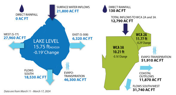
For the seven-day period March 11-17, there was no direct rainfall into the big lake, according to the South Florida Water Management update released March 20.
Surface inflows from the north into Lake O totaled 21,800 acre feet. The U.S. Army Corps of Engineers continues to send water south from Lake Kissimmee to keep that lake’s water level low enough to make repairs to a water control structure.
Most of the water that left the lake March 11-17 was via evapotranspiration, a combination of evaporation and plant transpiration. The lake lost 46,300 acre feet via evapotranspiration over the seven-day period. In that same period, 18,530 acre feet flowed south for irrigation and water supply. 6,320 acre feet flowed east to the St. Lucie River; and 27,960 acre feet flowed west to the Caloosahatchee River.
South of the lake, direct rainfall was light with just 130 acre feet of rain falling on Water Conservation Areas (WCAs) 3A and 2A.
Evapotranspiration removed 51,910 acre feet of water from the WCAs.
Coastal outflows from the WCAs totaled 11,870 acre feet. Flows southwest under the Tamiami Trail to Everglades National Park totaled 31,740 acre feet.
WCA 2A and 3A are still above schedule, due to heavy rainfall earlier in the “dry” season. The WCAs are north of the Tamiami Trail, which acts as a dam across the Everglades from Tampa to Miami. Although there are some culverts and raised sections of the roadway, there is not sufficient flow capacity under the road to prevent water from stacking up in the WCAs.
On March 20, Lake Okeechobee was 15.62 feet above sea level. That’s more than a foot higher than the historical average for March 20.
The U.S. Army Corps of Engineers (USACE) has set the target flow at the Julian Keen Jr. Lock at Moore Haven at an average of 4,000 cubic feet per second. Pulse releases are used to mimic the system’s natural flow. For the seven-day period ending March 20, the average flow was 2,003 cfs.
The USACE has set the target flow at the St. Lucie Lock at 1,800 cfs. For the seven-day period ending March 20, the average flow was 156 cfs.
The average flow from the lake south for that same period was 1,941 cfs.
Lake Okeechobee has a surface area of 730 square miles or about 468,000 acres.
Lake O has been high since September 2022 when floodwaters from Hurricane Ian were pumped down the Kissimmee Chain of Lakes into the Big O to prevent homes in Orlando/Kissimmee from flooding. After the storm passed, the lake rose several feet. For the rest of 2022 and all of 2023, the lake stayed high as USACE prioritized the health of the Caloosahatchee and St. Lucie estuaries and limited freshwater releases to the Caloosahatchee from Lake Okeechobee to the beneficial flow the river requires in the dry season.
According to RECOVER, the lake’s normal ecological envelope ranges from 12 feet at the end of the dry season to 15 feet at the end of the wet season. The lake’s recovery envelope uses a low of 11.5 to 12.5 and a high of 14.5 to 15.5.
RECOVER (REstoration COordination & VERification) is a multi-agency team of scientists, modelers, planners and resource specialists who organize and apply scientific and technical information in ways that are essential in supporting the objectives of the Comprehensive Everglades Restoration Plan (CERP).
The lowest Lake O level in 2023 was 13.7 feet.