The Lower Kissimmee Basin Stormwater Treatment Area project continues to attract debate ..
Join our family of readers for as little as $5 per month and support local, unbiased journalism.
Already have an account? Log in to continue. Otherwise, follow the link below to join.
Please log in to continue |
Okeechobee County Commissioners, along with residents of the Lazy 7, Sunset Airstrip and River Oaks subdivisions, have questioned the location of the planned STA -- just a short distance from airstrips and homes. Some nearby property owners are worried that it might impact water tables or flood maps. Pilots have raised concern the large STA will attract birds which could increase the risk of bird strikes on airplanes. County commissioners have also questioned the cost of the project a cost of “not to exceed $300 million.”
Water managers maintain the site on the east side of the Kissimmee River, just south of SR 70 is ideal because it could clean water from the river year-round as well as clean the water from the L-62 canal in the wet season. They point to the high nutrient load in the L-62 canal.
Okeechobee officials have asked: Isn’t there a more cost-effective way to remove the phosphorus before it goes into Lake O? They suggested investing money in septic-to-sewer projects, using the AguaCulture system to use plants to clean water or even using heavy equipment to dig out phosphorus deposits.
They ask: Before spending $300 million in tax dollars to clean up water before it enters the lake, should we invest more time and money into finding the source of the phosphorus in water from the L-62 canal?
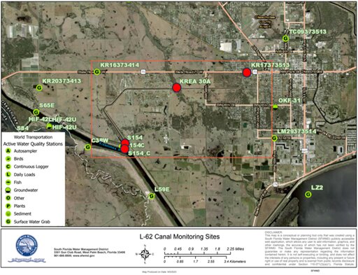
SFWMD samples water at four monitoring stations (in red on the map KR17373513, KREA 30A, S154, and S154-C) along the L-62 canal and one additional monitoring site (KR16373414) that flows southwards into the L-62 canal. Of the five monitoring sites, stations KR17373513 and KREA30A are located on the northern extent of the L-62 canal, KR13673414 is where a small tributary crosses under SR 70 crossing, and S154 and S154-C are located where the L-62 canal deposits into the Kissimmee River (C-38).
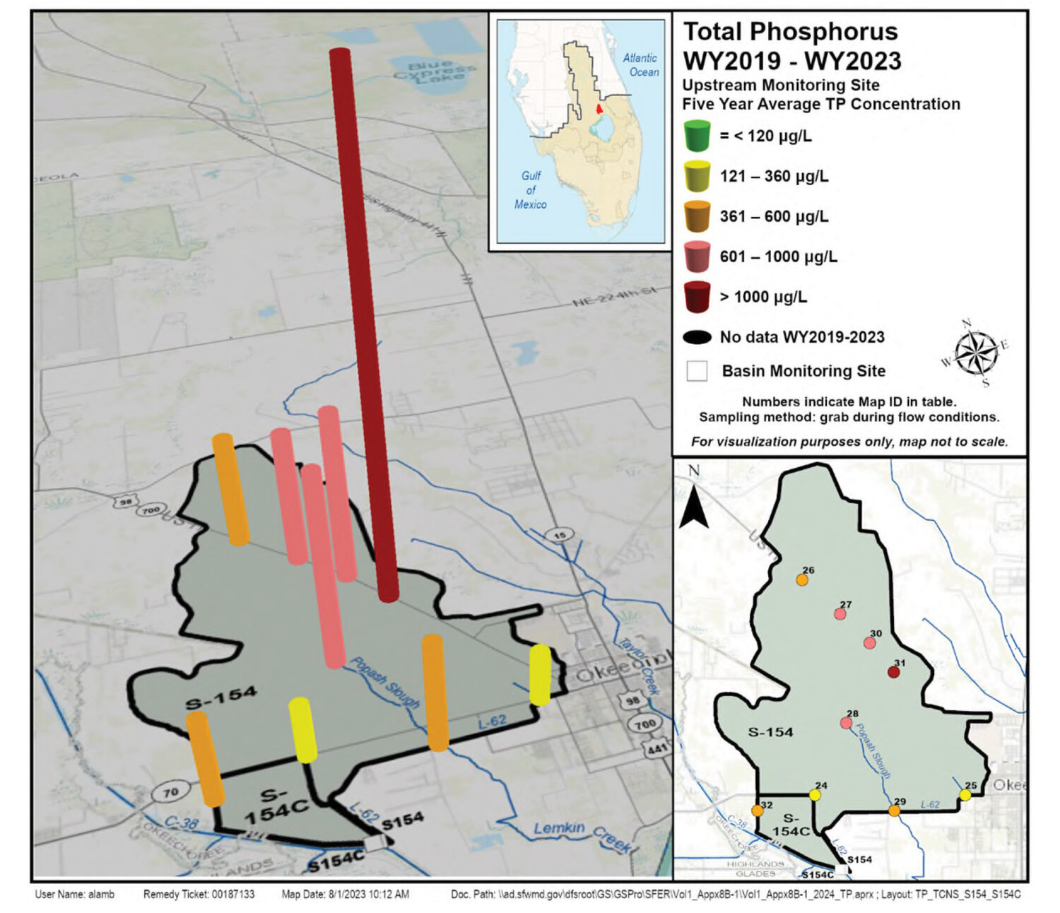
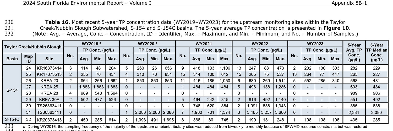
The South Florida Environmental Report (SFER) provides the phosphorus averages for the collection sites for the most recent 5-year period (2019-2023). Water years are May 1 to April 30. WY 2023 ended April 30, 2023.
• KR13673414: Phosphorus average for 2019-2023 was 282 ppb.
• KR17373513 – Phosphorus average for 2019-2023 was 265 ppb.
• KREA 30A: Phosphorus average in 2019 was 502 ppb; no data for 2020; average in 2021 was 464 ppb; average in 2022 was 816 ppb; no data for 2023. Five-year average: 551 ppb.
• S-154 C: Five-year phosphorus average for 2019-2023 was 435 ppb.
While all the samples are high in phosphorus, the phosphorus level appears to increase dramatically at the KREA 30A site. This is where Popash Slough meets the L-62 canal.
The goal for the L-62 sampling stations is 120 parts per billion (ppb). The goal for water in Lake Okeechobee is 40 ppb. Higher phosphorus levels upset the natural balance of plant life in the lake. Higher phosphorus levels (along with available nitrogen in the water, warm weather and lack of water movement) also increase the chance that cyanobacteria (commonly called blue-green algae) naturally found in Lake O will reproduce rapidly into a "bloom." Of the 28 species of blue-green algae documented by the U.S. Geological Survey in the Lake Okeechobee Waterway, about 25% are capable of producing toxins. While blue-green algae capable of producing toxins do not always do so, bloom conditions increase the chance of toxin production.
The SFER has no data for the collection point at the northmost point of Popash Slough for 2020, 2021, 2022 or 2023. In 2019, phosphorus levels at that point averaged 989 ppb.
Where is the phosphorus coming from? Is it possible to track it down?
In the 1980s, high phosphorus levels in runoff from the basin were blamed on the dairies. In 1986, the Florida Department of Environmental Protection (FDEP) Dairy Rule put strict limits on the phosphorus levels in dairy runoff, and a dairy buyout program was set up for those who could not meet the new standards. Most of the dairies left the watershed, and those that remain have systems to control and recycle the runoff. At the time of the dairy buyout, scientists theorized it would take 20 years for phosphorus levels in the basin to decline. That was more than 35 years ago. Could the larger problem come from something besides those long-gone cows?
Want to learn more about "legacy" phosphorus?
Disclosure: Katrina Elsken lives in the Sunset Airstrip subdivision.